Trekking - Annapurna - Annnapurna Tilicho Lake
Annnapurna Tilicho Lake Trekking (25 Days)
Trip Facts
 Trekking Type: Camping Trek
Trekking Grade: ▲▲▲ (?)
Maximum Altitude: 4930 m.
Best Season: October - November, March - May
Trekking Itinerary
Day 01: Arrive Kathmandu and transfer to Hotel .
Day 02:Sightseeing Pashupatinath, Patan, Kathmandu city and evening to Swayambhu Stupa and Back to Hotel.
Day 03 : Freeday in Kathmandu.
Day 04:Bensisahar (820m), 7 hours drive. After your Break fast around 7-30 Am. Moving with your trekking guide from the Hotel with Taxi drive to Local Bus station in Gongabu and by local mini express bus to Bensishahar 7 hours drive this day Lunch will be Pack lunch which you will take from the hotel. And overnight in nice Hotel in Bensisahar Lamjung.
Day 05 : Trek to Bahundanda (1310m.) 6 ½ hours. .) From Besi Sahar the trail descends sharply then climbs steeply through the deep gorge. It moves up and down through fields, tropical forest and small hamlets to khudi at 845m, the first Gurung village. Most people are Brahmin or Chettri with a few Gurung villages. Northwards up the Marsyangdi valley cross over a suspension bridge in Bulbule Good views of Manaslu and Ngadi Chuli. Ngadi is a small settlement mix people and you will have to cross very high suspension bridge over the Ngadi River and rightside gradually uphill about 1 and ½ hours to get Bahundanda.
Day 06 : Trek to Jagat. (1300m.) 6 hours.
Follow the trail marked signs, at first Descent to a stream is along a steep, slippery trail then pass a huge slide area to khane at 1180m. flocks still following the Marshyangdi River climbing gradually except where necessary to cross steep ridges till suddenly the valley opens on to a wide plateau again cross the Suspension bridge on Syange on Marshyangdi River and right turn again beyond the Marsyangdi river bank and gradually uphill to Jagat.
Day 07 : Trek to Dharapani (1860m.) 6 ½ hours. The trail continues zigzag way across the rightside Marsyangdi river view and after crossing again suspension bridge in the Marsyangdi river the trail goes uphill and gradually steep flat and get to Taal. Taal is one of the famous place for valley views and water falls. You will have to take lunch break here in Taal with the water fall scenery. And after lunch continue to Dharapani with passing several local villages and crossing many places on the Marsyangdi river bridge. For 5th times we have to cross on the Marsyangdi river bridge this day. Dharapani is one junction way for Manaslu round also this is very nice place.
Day 08: Trek to Chame (2670m) 6 hours. The trail is rocky and rough but suddenly a broad level stretch appears. A fine wooden bridge near a waterfall and out standing stone work supports the trail. Tyangja, also known as lattamanang appears at 2360m. The track stays near Marsyangdi in forests of oak and maple, climbing and descending between water worn boulders to cross a large stream into Kyupar.
Day 09 : Trek to Lower Pisang (3200m.) 6 hours.The next village is Chame at 2630m, HQ of the regional administration with good views of lamjung and Annapurnas II and IV. From here cross a stream and then the Marsyangdi itself on a large suspension bridge and continue up the north side of the river to talung and later, through apple orchard to Bratang, a now largely abandoned Khampa settlement. Return to the trail across the bridge and follow the new trail that has been blasted out of the cliff face through a narrow and steep valley. Pass through deep forest then cross to the south side of the river on a long suspension bridge at 3040m. There is a dramatic first view of the Paungda Danda rock face rising 1500m from the river. Over a ridge marked by prayer flags and stone cairn, continue the steep ascent to the upper Marsyangdi. The lower sections of Pisang appear as a cluster of homes with a long Mani wall
Day 10 : Trek to Manang (3540m) by visiting Ngawal monastry with enjoying mountain views left side and to Manang 7 hours. A short distance beyond Pisang the trail climbs a steep ridge right side of the Marsyangdi River to get Ngawal but it is one of the really great viewing point o f the whole Annapurna Ridge and the Marsyangdi river valley view.
Day 11 : Trek to Khangsar (3610m) 4 hours. After breakfast Spend the time at Manang in order to acclimatize yourself for crossing over the Tilicho pass. It is possible to cross the ridge north of Annapurna IV, II, and Glacier Dome or to descend from village to the glacial lake at the foot of a huge icefall descending from the northern slopes of Gangapurna. Manang village itself is compact collection of slightly over 500 flat roofed houses whose entrances are reached from the narrow alleys that interweave among them by ascending a steep log notched with steps. And after lunch moving to Khangsar.
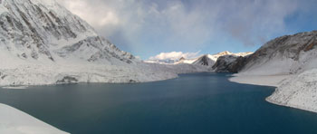
Day 12: Trek to Tilicho lake (4930m) which is holy lake due to Guru Ringpuche bathing place so, normally every year Pilligrimage festival in August. 6 hours. Overnight in nice lodge.
Day 13:Day Excorations to small peaks and lake and overnight in lodge.
Day 14: Trek to Jomsom (2770m) after 2 pass the pass is 5180m pass and other is 4950m pass. 8 hours.
Day 15: Trek to Kalopani (2540m) 7 hours walk. About the trail description these day not up and down way must of flat, the way follows the kaligandaki river from on the way we will see very nice view on the right side dhaulagiri ice fall, Dhaulagiri 1, Thapa peak , Tuckche peak, and left side Nilgiri north, Nilgiri west, and Tilichok peak. Left side of infront nice hills with green forest valley and wide valley of the kaligandaki. and also we will pass for about 5 villages with coulourful temple, stupas on the way.
Day 16: Trek to TATOPANI (1190M.) 7 hours walk. This day is Long way to get Tatopani , early morning from Kalopani and Lete is very nice view again Dhaulagiri Glacier, Dhaulagiri 1, Nilgiri north, Nilgiri west, Annapurna 1, and the Trail also is many Zigzag and Rocky also most of down hill, passing many village on the way, and Kaligandaki deepest gorge you will be in this day. and the rupsi chahara is one of the best lunch place with the cool blowing water vapour you will have lunch here. this day is hot temperature because of getting in lower height.
Day 17: Trek to Ghorepani (2750m.) 7 hours walk. This day is will have to start early morning also arround 7o' clock because we leave kaligandaki valley and climbing leftside to gorepani in the begginging of starting to climbing about 1 and half hour is uphill steep uphill and after slide up to the Ghara the Mix village passing and we get sikha all mangar village there we will see again the mountains backside and valley of the Kaligandaki and also lunch here. Until here will be hot but after here will be cold. Ghorepani is One of the such great view point of Annapurna region trek, Left side we see many mountains of Machhapuchre, Annapurna1, Annapurna 3, whole Annapurna and Manaslu also and Right Side whole Dhaulagiri and Kaligandaki valley very nice place.
Day 18: Trek to Tadapani (2520m.) 5 hours walk. This day early morning about 5 o'clock we have to go to Poonhill about one hour to Get to the Poonhill 3200m the best panoramic view for sunrise and mountain green valley view. You will enjoy to see these magnificiant view about half and hour and back to camp Ghorepani it will take half an hour and have breakfast and after breakfast starting walk to Tadapani also from camp side about 40 minutes is uphill and get to the Ridge about same view from the Poon hill and after deurali it get to the valley down in forest following stream (small River) and get Bunthanti is 20 minutes flat and 10 minutes down and 30 minutes up and you will get to the Tadapani this day is you walk in real colourful rhododhendron forest. This is best day for see the view and many different flowers.
Day 19: Trek to Landruk (1670m) 6 and ½ hours walk
This day the trail goes about 3 hours down hill to the jhinu where is another hot spring called Himal pani from the Jhinu 15 minutes north down hill to Modi river side there is the hot spring bathing place with the river gods temple. It is through the Jungle and 90% chance to see the wild animals like monkey and others and the way go from Jhinu still down through the Bamboo forest about 30 minutes and cross the suspension bridge in Burjung khola and slightly up and down get to new Bridge where is settlement of few Mangar lodge with nice water fall and modi river view through the Jungle go uphill to Landruk. Landruk is very old village where is settlement of mix peoples with very nice view of mountains river and village.
Day 20: Trek to Dhampush (1770m.) 6 hours walk.
This day from the beginning way goes zigzag up and down and slightly up through the many tea house cross the many of the suspension small bridge Tolka the tolka is settlement of Mangar and chettri Brahman peoples here is a high school very old they are asking always donation for the school but not compulsory to give it's upto you but the people is very frankly and helpful also on the way. Pothana is gurung village between the big forest with colourful view going slightly down and straight to the Dhampus. Dhampus is most of Gurung peoples and chettri brahaman one of the very famous view point in this area also last view point of according this trekking route.
Day 21: Pokhara (950m) 2 hours walk down hill to Phedi and 45 minutes drive
to Pokhara overnight at hotel\camp.
Day 22: After breakfast sightseeing in Pokhara like : Mahendra cave, Bindabashini Temple, David fall, Tibetan Refugee camp and World peace Stupa for the View.
Day 23: Drive\Fly to kathmandu.
Day 24: Free day in Kathmandu.
Day 25: Final Departure transfer to International Airport.

© 2008 Adventure Geo Treks. All Right Reserved.
Design by Nepal Media Network | Valid XHTML 1.0