Trekking - Annapurna - Annapurna Circuit Trek
Annapurna Circuit Trek (20 Days)
Trip Facts
 Trekking Type: Lodge/Camping Trek
Trekking Grade: ▲▲▲ (?)
Maximum Altitude: 5416 m.
Best Season: October - November, March - April
Trekking Itinerary
Day 01:
First day Arrival in Kathmandu and pick up in international Airport and welcome greet to Nepal with a flower garland and by private transport, transfer to Hotel Harati and check in your hotel garden side A.c. deluxe Room in bb.(bed and break fast) and evening welcome dinner with trek briefings and overnight Hotel.
Day 02: Kathmandu -to-Benshishahar (820m).
6 hours drive with local super express from your hotel after the breakfast private transportation will drop to the bus station. With all porters and guide will be going together in same Bus. pack lunck will be feeding on the bus, over night in Bensi sahar at the Lodge.
Day 03: NGADI (930m.)
From Besisahar the trail descends sharply then climbs steeply through the deep gorge. It moves up and down through fields, tropical forest and small hamlets to khudi at 845m, the first Gurung village. Most people are Brahmin or Chetri with a few Gurung villages. Northwards up the Marsyangdi valley cross over a suspension bridge in Bulbule Good views of Manaslu and Ngadi Chuli. Ngadi is a small settlement in lodge overnight.
Day 04: SYANGE (1100m.)
Cross the long suspension bridge over the Ngadi Khola. Follow the trail marked signs saying “manang”and climb gradually at first and steeply the last bit as it moves through scrub forest into Bahundanda.Descent to a stream is along a steep, slippery trail then pass a huge slide area to khane at 1180m. Flocks still following the Marshyangdi River climbing gradually except where necessary to cross steep ridges till suddenly the valley opens on to a wide plateau. Tall lies at the food of a picturesque waterfall at 1675m.overnight in the lodge.
Day 05: BAGARCHAP (2160m.)
The trail continues across the plateau beyond tall over a forested ridge and across a bridge to Dhharapani at 1890m. Two hour beyond Dharapani lies Bagarchhap.The trail continues through fine forest full of birds, through Dhanakyu to Temung phedi, a settlement with several hotels.
Day 06: (CHAME (2670m.)
The trail is rocky and rough but suddenly a broad level stretch appears. A fine wooden bridge near a waterfall and out standing stonework supports the trail. Tyangja, also known as lattamanang appears at 2360m. The track stays near Marsyangdi in forests of oak and maple, climbing and descending between water worn boulders to cross a large stream into Kyupar.in good lodge overnight.
Day 07: PISANG (3200m.)
The next village is Chame at 2630m, HQ of the regional administration with good views of lamjung and Annapurnas II and IV. From here cross a stream and then the Marsyangdi itself on a large suspension bridge and continue up the north side of the river to talung and later, through apple orchard to Bratang, a now largely abandoned Khampa settlement. Return to the trail across the bridge and follow the new trail that has been blasted out of the cliff face through a narrow and steep valley. Pass through deep forest then cross to the south side of the river on a long suspension bridge at 3040mThere is a dramatic first view of the Paungda Danda rock face rising 1500m from the river. Over a ridge marked by prayer flags and stone cairn, continue the steep ascent to the upper Marsyangdi. The lower sections of Pisang appear as a cluster of homes with a long Mani wall. . Overnight in good lodge.
Day 08: MANANG (3540M.)
A short distance beyond Pisang the trail climbs a steep ridge that extends across the valley. Make a short descent than walk along the flat trail passing the airstrip of Hongde and overnight in Manang a best lodge in Manang yeti lodge.
Day 09: MANANG (3540M.):
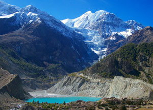
Spend the day at Manang in order to acclimatize yourself for crossing over the thorang la. It is possible to cross the ridge north of Annapurna IV, II, and Glacier Dome or to descend from village to the glacial lake at the foot of a huge icefall descending from the northern slopes of Gangapurna. Manang village itself is compact collection of slightly over 500 flat roofed houses whose entrances are reached from the narrow alleys that interweave among them by ascending a steep log notched with steps. Overnight yeti lodge.
Day 10: THRONG BASE CAMP (4450M.)
The trek now begins the 1800 meters ascent to Throng La. Begin by climbing up to the upper portion of Manang village, then climb out of Marsyangdi valley and turn northwest. The trail now goes north passing through scrub juniper and alpine grasses. After passing the last shelter, a two storey stone house, the trail ascends less steeply then crosses the Jarsang Khola on a small wooden bridge at 4300m. This is the best viewpoint area on this side of the pass.overnight Hotel.
Day 11: MUKTINATH (3800M.)
The trail is comes steep immediately after leaving the Hotel, up moraines and following rocky ridges as it ascends to the pass. As this trail was once followed by local people for hundred of years, the trail although steep is well defined and easy to follow. The only complication is the high elevation and the possibility of snow. The pass with its traditional chorten and stone cairn built by travelers is reached at 5416 metres about four hours from the last hotelThe descent is steep – a loss of more than 1600 metres in less than three hours. The trail begins the descent in snow, which changes into moraines, and then finally yield to grassy slopes and the final descent to muktinath is a pleasant walk along the upper part of Jhong khola valley.
Muktinath is an important pilgrimage place for both Hindus and Buddhists a like sited in a grove of trees the holy shrines at muktinath include a Buddhist gompa and the pagoda style temple of Jwala Mai containing an image of bishnu. Camp near the guesthouse.
Day 12: Marpha (2670M.)
This day the way about 6 hours walk and we pass through and begin a steep descent to the floor of the valley. The trail is now the world’s deepest gorge and follows this to Tukche. However, your trip is through the village of Kagbeni. The kagbeni is very old village and have very old monastery and the colourful pray flag on the roof of the houses and looks very different colours, very old house and such nice Landscape in this valley the way divided from here to Mustang also about half hour you have to spend here for looking round the village and visit to monastery the monastery entrance fee it cost 100 rupees for tourist per person after your visit through the Jomsom it takes about 4 hours way to walk to Marpha, following the kaligandaki wide valley with the very nice view of Tilichok and Nilgiri North with the dry landscape but these day starting from Muktinath would be good in early morning about 7 o'clock. because in afternoon in this valley daily very strong wind blows pushing you backward.
Day 13: KALOPANI (2540M.)
6 ½ hours walk About the trail description these day not up and down way must of flat, the way follows the kaligandaki river from on the way we will see very nice view on the right side of Dhaulagiri ice fall, Dhaulagiri 1, Thapa peak, Tuckche peak, and left side Nilgiri north, Nilgiri west, and Tilichok peak. Left side of in front nice hills with green forest valley and wide valley of the kaligandaki. And also we will pass for about 5 villages with colorful temple, stupas on the way. Very nice lodge in kalopani.
Day 14: TATOPANI (1190M.)
7 hours walk This day is Long way to get Tatopani, early morning from Kalopani and Lete is very nice view again Dhaulagiri Glacier, Dhaulagiri 1, Nilgiri north, Nilgiri west, Annapurna 1, and the Trail also is many Zigzag and Rocky also most of down hill, passing many village on the way, and Kaligandaki deepest gorge you will be in this day. And the rupsi chahara is one of the best lunch places with the cool blowing water vapour you will have lunch here. This day is hot temperature because of getting in lower height. Good hotel.
Day 15: Ghorepani (2750m.)
7 hours walk This day is will have to start early morning also around 7o' clock because we leave kaligandaki valley and climbing left side to gorepani in the beginning of starting to climbing about 1 and half hour is uphill steep uphill and after slide up to the Ghara the Mix village passing and we get sikha all mangar village there we will see again the mountains backside and valley of the Kaligandaki and also lunch here. Until here will be hot but after here will be cold. Ghorepani is One of the such great view point of Annapurna region trek, Left side we see many mountains of Machhapuchre, Annapurna1, Annapurna 3, whole Annapurna and Manaslu also and Right Side whole Dhaulagiri and Kaligandaki valley very nice place.
Day 16: Tadapani (2520m.)
5 hours walk This day early morning about 5 o'clock we have to go to Poonhill about one hour to Get to the Poonhill 3200m top for the best panoramic view for sunrise and mountain green valley view. You will enjoy to see these magnificiant view about half and hour and back to camp Ghorepani it will take half an hour and have breakfast and after breakfast starting walk to Tadapani also from camp side about 40 minutes is uphill and get to the Ridge about same view from the Poon hill and after deurali it get to the valley down in forest following stream (small River) and get Banthanti is 20 minutes flat and 20 minutes down and 30 minutes up and you will get to the Tadapani this day is you walk in real colourful rhododhendron forest. This is best day for see the view and many different flowers. Supperview lodge.
Day 17: Landruck (1670m) 5-6 hours walk.
Day 18: Pokhara (950m)
Trek to Dhampus phedi 6 hours and 1 hour drive back to pokhara. Pokhara is one of the big towns in Nepal with the all round mountains panoramic views and lakes and several places are interesting to doing sight seeing davit fall and Tibetan refugi camp and lake barahi temple with the panoramic Mountain and lake and pokhara view point of Japanese stupa. Overnight in Hotel.
Day 19: Katmandu (1300m) drive by tourist bus and transfer to your hotel Harati. o/n hotel.
Day 20: According to your departure time departure transport to the international airport.

© 2008 Adventure Geo Treks. All Right Reserved.
Design by Nepal Media Network | Valid XHTML 1.0